This blog is a listing with the idea of catalogueing all Rhine leporello maps published before 1900. If you think you can help with useful information, please contact me.
On the following pages you will find a listing of all the maps of the Rhine which I have researched or collected over the years. You will find over 60 maps listed here from Sir John Carr's map included in his travel book published in 1807 to a selection of Rhine leporellos printed and published in the early 20th century.
Numbering system:
The numbering is based very much on Sattler (see below) with a slight amount of variation and flexibility which I have allowed myself. It is my private numbering system. Sattler, in his very solid listing prepared for an exhibition of Rhine maps held in Cologne (1995), used a lettering system from A - N. I have attempted to incorporate this in my own listing. However, I have added an extra category AA for precursors to Rhine strip maps in order to show just a few examples of the genre which was existant before Delkenkamp's breakthrough of the leporello map. For those not familiar with the term, a leporello is simply a long fold out strip and was popularly used for photo albums in the late nineteenth century in many countries. It was the use of this technique to represent the Rhine river which was a great breakthrough.
My aim when I began collecting panorama maps of the Rhine was to concentrate on the years up to and around the end of the nineteenth century, hence my numbering finishes with category I. As well as information on the map or maps in my collection - which I am selling - you will also find information on variant states which I have come across or versions which I believe to exist. If you can add to the information on these pages please do contact me.
Click link to access pages directly
AA. Early Rhine maps
A. The original Rhine Panorama as strip map
B. First Rhine panoramas – leporellos with no illustrations
C. The introduction of the side illustrations
D. Experiments
E. Simplification
F. Masterpieces of steel engraving
G. Masterpieces of lithography
H. Photolithographic colour – single tone, blue or sepia
I. Commercialisation - full colour and cheap printing
I have used the following sources extensively. I apologise if I have quoted without using strict reference guidelines.
Holzhäuer, Hanne: Der Rhein im Panorama - 1825 bis heute: Badische Landesbibliothek: 2002.
Sattler, Alfred: Rheinpanoramen - Reisehilfen und Souvenirs: Verkehrsamtes der Stadt Köln: 1993. Catalogue to accompany the exhibition of the same name.
Sattler, Alfred: Rheinpanoramen - Reisehilfen und Souvenirs: Alfred Sattler: 1995. Catalogue/Handout produced for the 10th Kölner Antiquariatsmesse.
Zögner, Lothar: Flüsse im Herzen Europas: Kartenabteilung der Staatsbibliothek zu Berlin: 1993. Catalogue to accompany exhibition held in four locations - Bonn-Bad Godesberg, Berlin, Bremerhaven and Regensburg.
ANNOUNCEMENT (2023)
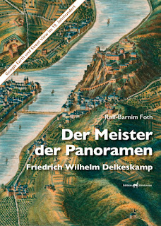
Master of the Panorama
Der Meister der Panoramen
Linked to my blog describing the various leporello maps of the Rhine, Rolf-Barnim Foth has written a highly interesting account of the life of F W Delkeskamp, the father of the fold-out leporello map, and his exploits in Switzerland, where he spent years mapping the scenery. Now, the book is available FREE in English as a PDF file.
Highly recommended:
If you were talking to three strangers and the first said that they had invented a new style of map which folded so neatly into your pocket that everyone would want it: and the second claimed to have climbed every single mountain and hill in Switzerland; and then the third of your companions recounts that they produced maps better and more accurately than google maps but their idea was admired but ignored and then forgotten; you might be forgiven for believing none! Far fetched? Yes, but only because you only needed Friedrich Delkeskamp at that table: and he did all three things in the early to late 1800s.
Rolf-Barnim Foth comprehensive biography of Friedrich Wilhelm Delkeskamp graphically describes the life and work of this largely unforgotten master. Rolf´s part bibliography, part cartobibliography appeared privately printed and published by Edition Kentavros under the magnanimous support of the Stiftung (Foundation) of Fehlmann of Winterthur in Switzerland in 2022 in German as Der Meister der Panoramen Friedrich Wilhelm Delkeskamp. The book is available in German from Edition Kentavros (see below). The book has now been translated into English and is available FREE as a .pdf file in A4 format. Fully illustrated (but at slightly reduced resolution).
In Frankfurt from 1823 he began work for the Wilmans publishing company, providing highly attractive views “drawn from nature”. He was already an accomplished artist and engraver and he was soon able to sign most of his work, not so usual at the time. Either he or Wilmans could have been made aware of an engraving of a small part of the Rhine river published as a “birds-eye” view and executed by a very accomplished artist Susanna Maria Rebecca Elisabeth von Adlerflycht (1775-1846). Delkeskamp´s idea was to produce a similar view but more realistically and again drawn from nature of a much longer stretch of the river. Consequently, after much hard work - travelling along the banks of the river sketching in the summer months, completing the engraving in the winter – a series of Rhine panoramas appeared from 1825 to 1837, similar leporellos, or the characteristic long fold-out plans, of the Mosel and the area of Baden-Baden were published. If they were attractive and novel when they first appeared, showing the long and winding river in a straight line, by the time the later series were started the blank areas at the sides of the river were filled with delightful views. An instant hit with public and critic, they were miniature works of art.
All of Delkeskamp´s trials and tribulations are revealed in Rolf Foth´s book and it is so full of illustrations that one wonders at the genius of the artist he is portraying. So many documents relating to Delkeskamp are not only illustrated but also painstakingly transcribed, and in the newly revised second working translated. The original German version at 310 x 240 mm is crammed with views and watercolours by the artist from archives throughout Europe and although somewhat smaller in the English version (A4) are printed in a resolution which allows full appreciation of his work. Many of the panoramas are reproduced fully over 10 pages.
If the Rhine panoramas which bear his name were Delkeskamp´s only achievement it would be sufficient to want to learn more about him, but the story continues. Having travelled to Switzerland at an early age, FWD fell in love with the mountains and from 1837 until the mid-1850s Delkeskamp worked on his Malerisches Relief der Schweizer Alpen or Picturesque Relief Map of the Swiss Alps. Executed on 10 full and 3 half sheets, the map covers a broad expanse of Switzerland in a detail that few had achieved for any country before him.
Plagued by financial problems due to his single-handed attempt to map Switzerland, he was living off the revenue coming in from his Rhine panoramas, but this income was being eroded due to the publication by pirate operators copying his work and undercutting his prices. Undeterred, he began his next epic adventure: to map the city of Frankfurt at an unprecedented scale and accuracy. The completed work is recreated here in facsimile over 15 complete pages. Every house, every garden and almost every tree has been lovingly engraved and one has the feeling that google earth is no real competitor.
Met with universal approval it failed to achieve any commercial success. Friedrich Delkeskamp died not in poverty but certainly in dire straits in 1872. This book was a tribute to him and published in 2022 exactly 150 years later. Packed full of information there are full annotations of sources as you would expect and a complete cartobibliography of his maps and drawings.
Now translated into English and edited accordingly.
The book in both forms and languages has been a labour of love for the author and he is happy for the work to be distributed as widely as possible. The original German issue and the English version were supported by the Fehlmann Foundation.
If you would like a free copy of the A4 version in English at lower resolution: click here
To order the original English version in larger format at full image resolution (€39.80 from most EU countries): click here.
To order the original German version in larger format at full image resolution (€44.80 from most EU countries): click here.Blog Disclaimer
My contribution to small print! This is a personal blog and I am responsible for both content and any mistakes. Corrections welcome!
All content provided on this blog is for informational purposes only. The owner of this blog makes no representations as to the accuracy or completeness of any information on this site or found by following any link on this site. The owner will not be liable in any legal interpretation for any errors or omissions in this information nor for the availability of this information. The owner will not be liable for any losses, injuries, or damages from the display or use of this information. If you choose to quote my work I will be, of course, be flattered: however, I will expect you to quote your source and observe the usual blog protocol.
Illustrations
Unless stated, all photos are from my own collection of images. Most are from maps and books that are, or were, in my collection. I am perfectly happy for you to use the images on a non-profit-making basis in your own work. Again: observe web protocol and quote your source. Where I have indicated that the image is from an outside source, this means I have contacted that institution or person and these images are copyright with all rights reserved. Reproducing these images may infringe copyright regulations. The user is responsible for complying with copyright rules. Please check the List of Illustrations on each blog.
Downloadable Files
Any downloadable file, including but not limited to text and image such as pdf, doc, jpeg, png, is provided at the user’s own risk. The owner will not be liable for any losses, injuries, or damages resulting from a corrupted or damaged file.
Comments
Comments are welcome. However, I reserve the right to edit or delete any comments submitted to this blog without notice where I deem it to be spam or questionable spam, contains language or concepts that could be deemed offensive, and of course where comments contain hate speech or similar.
The blog owner is not responsible for the content in comments.
This policy is subject to change at anytime.


