
Rhine panoramas
without side illustrations
The following maps were produced between 1825 and 1880. The first Rhine leporello was produced by Delkeskamp in 1825 and although vignettes appeared in the margins in order to make the maps more attractive as early as 1838 the non-illustrated leporello continued to be printed and publishing well into the twentieth century.
At the time of the first leporellos there were only three "fixed" crossing places in order to cross the Rhine (apart from boat transport). These were at Cologne, Koblenz and at Mainz: the latter two each had a pontoon bridge composed of a number of boats which were held together and swung across the river using the current. The first truly fixed bridge on this stretch of the Rhine, and the only permanent bridge portrayed on the majority of the early panoramas, was built at Cologne in 1822, the so-called Deutzer Bridge.
At the time of the first leporellos there were only three "fixed" crossing places in order to cross the Rhine (apart from boat transport). These were at Cologne, Koblenz and at Mainz: the latter two each had a pontoon bridge composed of a number of boats which were held together and swung across the river using the current. The first truly fixed bridge on this stretch of the Rhine, and the only permanent bridge portrayed on the majority of the early panoramas, was built at Cologne in 1822, the so-called Deutzer Bridge.
Between 1855 and 1865 three new bridges were completed. The Hohenzollern
Bridge at Köln was built between 1855 and 1859; the railway bridge at Mainz was
completed in 1864 according to designs by Gerber; and the Pfaffendorferbrücke
just south of Koblenz was opened in 1864 after three years´ construction. The progress of the bridges and also of the railway help to date some of those maps which were up to date.
B. 1.
Delkeskamp I - Geiler
|
1825
|
B. 2.
Delkeskamp Ia - Geiler copy
|
1825
|
B. 3.
Audin
|
1828
|
B. 4.
Delkeskamp II - Helmsauer
|
1829
|
B. 5.
Helmsauer and Rosenkranz
|
1830
|
B. 6.
Anon
|
1830
|
B. 7. John Clark
|
1830
|
B. 8.
Delkeskamp III - Creutzbauer
|
1832
|
B. 9. Tombleson
|
1832
|
B.
10. Müller / Steiner
|
1835
|
B. 11. Kohnen
|
1840
|
B. 12.
Delkeskamp IV – Dauch
|
1865
|
B. 13.
Kapp I
|
1868
|
B. 14.
Halenza I
|
1870
|
B. 15. LeSimple I
|
1874
|
B. 16.
Hotel Disch
|
1880
|
B. 1. Delkeskamp
I - Geiler 1825
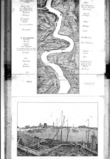
This is the first edition of Delkeskamp's first Rhine panorama (see also B.4, B.8 and B.12 as well as entries C.1, C.3 and C.4). Friedrich Wilhelm Delkeskamp (1794-1872), already a well-known artist and copper engraver, was engaged in the autumn of 1823 by the Frankfurt art dealer and publisher Friedrich Wilmans to work on a panorama of the stretch of the River Rhine between Mainz and Köln “nach der Natur” or according to nature in the same style as Elisabeth von Adlerflycht had employed. This enterprise was published in June 1825 as a copper engraving in Wilmans publishing house. Sattler 1993.
In producing this panorama Delkeskamp created the prototype of an extraordinary development which he lead over the next decades; first for Wilmans and later in his own publishing company. Delkeskamp laid down what was to become the classic journey from Mainz to Cologne (Köln). This particular map comprised seven leaves stuck together end-to-end. The extremely handy format allowed ease of use and these panoramas continued to be offered in this format - the Leporello. The artist is given as P Geiler, about whom little is known, and was the first of the Delkeskamp Rhine panoramas.
There was an accompanying text (14 pages): Der Begleiter auf der Reise von Mainz bis Köln. Ein nöthiger Anhang zum Panorama des Rheins und seinen nächsten Umgebungen.
There was an accompanying text (14 pages): Der Begleiter auf der Reise von Mainz bis Köln. Ein nöthiger Anhang zum Panorama des Rheins und seinen nächsten Umgebungen.
Cover
title
Panorama des Rheins
und seine nächsten Umgebungen von Mainz bis Cöln
The map folded into plain boards and was offered with the text booklet and sold in a plain card slipcase with title: Panorama des Rheins von Mainz bis
Cöln Nach der Natur aufgenommen und gestochen von F W Delkeskamp. Frankfurt am Main. 1825. bei Friedrich Wilmans. If anyone has a variant title I would be grateful for details.
Map
title
Panorama
des Rheins und seine nächsten Umgebungen von Mainz bis Cöln also with Nach der Natur
aufgenommen und gestochen von F W Delkeskamp.
Artist’s signature: P. Geiler fc.
Size
Engraving on 7 copper plates, 2340 x 230 (or
300) mm.
Kart. 17411 – Kartenabteilung der Staatsbibliothek zu Berlin
Rheinische landesbibliothek http://www.rlb.de/Digitalisate/Delkeskamp_Panorama
Flüsse im Herzen
Europas R48 (one sheet illustrated; Kart
L17588; page size is 270 x 550 mm; map is approx. 400 x 150 mm) and R49 (probably refer to same map)
Sattler, Rheinpanoramen B2 / 4A
Holzhäuer Der Rhein im Panorama 2 (p. 81 and illustrated detail Farbtafel 3)

Presentation copy (ill. in Holzhäuer)

Title section (Courtesy of Landesbibliothek Koblenz)
B. 2. Delkeskamp I Geiler - copy 1826
Cover title
No title but folds into plain card boards with cloth spine sliding into a slipcase
with paper label: Panorama des Rheins von
Mainz bis Cöln.
Map
title
Panorama des Rheins und seiner nächsten
Umgebungen von
Mainz bis Cöln (centrally
below with Mainz at bottom) in identical style as Delkeskamp I (see previous
entry). No signatures or imprint.
Size
Cover is 185 x 240 mm. Map is
approx. 2100 x 230 mm with the names of in a wide margin, river 150 mm wide.
Would appear to be a very close copy of the Delkeskamp. This example has
no head or tail views, as these were not included in Delkeskamp's first Rhine
panorama. Variations to Delkeskamp´s placenames include Chausseehaus beim
todten Juden or Rodderhof near Rothenkirchen (instead of Fort Nicolaus and Der
todte Jude, Rodenkirchen and Ins Rodekircher Werth od. Graf). Has the same
folding out section at Sieben Gebirge. Note omission of Mayence between Mainz and Citadelle on section illustrated.
Not in Flüsse im Herzen Europas.
Not in
Sattler, Rheinpanoramen
Holzhäuser p. 51.
See Holzhäuer p. 52 for info on
copyists. See also p. 55 for another copy circa 1829.

B.3. Audin 1828
Jean-Marie-Vincent Audin was born in Lyon in 1793 and died in 21st February 1851 (in Orange?) on the way back from a journey to Italy. He entered the church and attended a seminary before working as a priest in Grenoble and later in Lyon. He wrote many articles and spent a brief period in prison (1815). Among his works were histories of saints and leading religious figures, e.g. St. Bartholomew (1826), Luther (1839), Calvin (1841), Pope Leon X (1844) and even Henry VIII (1850). He also wrote a series of guide books (see section AA) under the pseudonym of Richard.
This would appear to be a very close copy of the Delkeskamp. Variations to Delkeskamp´s placenames include the omission of some of the small islands in the river, e.g. two are missing between Zunsdorf and Godorf below Cologne. Holzhäuser has Hocquart je as the lithographer and points out the numerous incorrect translations for French tourists at the sides of the titles (see illustration below - Courtesy of Goyert Gallery, Cologne).
Cover
Folds into plain card boards with title within a gothic arch decoration: Panorama des Bords du Rhin. Also an imprint: Paris, Audin, Quai des Augustins Nr 25.
Map
title
Size
Not in Flüsse im Herzen Europas.


B.4. Delkeskamp II –
Helmsauer 1829
Map
title
Panorama des Bords du Rhin (centrally below with Mainz at bottom) with panorama of the Rhine in
identical style as Delkeskamp I, including placing and writing of placenames. Imprint: AUDIN, PONTHIEU and
dated 1828.
Size
Cover is approximately 210 x 185
mm. Map is approx. 2200 x 210 mm with the names of in a wide margin.
Not in Flüsse im Herzen Europas.
Not in
Sattler, Rheinpanoramen
See Holzhäuer 6 and p. 54.


Cover title
Inside a paper wrapper with title:
Panorama du
Rhin: Mayence jusque á Cologne (with
label on reverse Mit König. Preussischem, Herzogl. Nassauischem und der freiem
Stadt Frankfurt am Main hullvolledst verliehenen Privilegien gegen den
Nachdruck und Nachstich versehen.) Folds into plain card boards with cloth spine. (Illustrations courtesy of Goyert Gallery, Cologne)
Map title
Size
Not in Flüsse im Herzen Europas.


B.5. Helmsauer / Rosenkranz 1830
Map title
Panorama des
Rheins und seiner nächster Umgebung von Mainz bis Coeln (centrally) below
scene of Mainz which is at bottom with title Original Ausgabe (below this) and
two signatures: aufgenommen von F W
Delkeskamp (left in thin circular panel) and gestochen von E A Helmsauer (right in thin circular panel) and
imprint centrally Frankfurt a/M Friedrich
Wilmans 1829.
Size
Cover (with title horizontal) is
180 x 250 mm. Map is approx. 2270 x 145 mm with the names of places taking up
all the remaining space. There is one extended section at Rolandseck requiring
folding inwards. View of Cologne at top and view of Mainz and title panel at
bottom.
Steel engraving on 9 plates,
2570 x 225 mm (Sattler).
Not in Flüsse im Herzen Europas.
Sattler, Rheinpanoramen B3 / 5B; exhibit N50 as example of binding.
Holzhäuer Der Rhein im Panorama 4 (p. 51 and 82 and illustrated detail)


B.5. Helmsauer / Rosenkranz 1830
Cover
title
Panorama des
Rheins: von Coeln bis Mainz
nach der Natur gezeichnet von Heinrich Rosenkranz, gestochen von C A Helmsauer.
Original
Ausgabe, (Repeated in French.) With
label on reverse Mit Kön. Preussischem, Herz. Nassauischem und der
freiem Stadt Frankfurt am Main hullvollest verliehenen Privilegien gegen den
Nachdruck und Nachstich versehen (repeated in French). Folds into plain card boards with cloth spine. (Goyert)
Map title
Size
Not in Flüsse im Herzen Europas.


B.6. Anon 1830
Map title
Panorama des
Rheins und seiner nächster Umgebung von Coeln bis Mainz (centrally but with Mainz at top) below scene of Coeln which is at
bottom and two signatures on next line: aufgenommen
von B Rosenkranz and gestochen von E
A Helmsauer with title Original
Ausgabe (below this) and imprint centrally Frankfurt a. M. bei Friedrich Wilmans 1830. Also publishers’
imprints of London, published by D
Walther, No. 4 Brydges Street, Coventgarden (left in thin circular panel)
and Paris chez Henry Rittner Boulevard,
Montmartre 12 (right in thin circular panel).
Would appear to be a further version of the Delkeskamp but notice the
new engravings top and bottom and the orientation. Helmsauer had gained experience with Delkeskamp (see previous entry) and now collaborated with Rosenkranz. The interest shown by the Anglo-Saxon visitors is shown already in the partnership with D Walther, obviously a London retailer.
Forty page booklet in German and
French (2 columns).
Size
Cover (with title vertical) is
180 x 235 mm. Map is approx. 1880 x 150 mm with the names of in a wide margin,
river 150 mm wide. View of Mainz at top and view of Cologne and title panel at
bottom.
Copper engraving on 8 plates,
2270 x 240 mm; head and tail views (Sattler).
Not in Flüsse im Herzen Europas.
Sattler, Rheinpanoramen N 50 / 5A (and illustration page 23).
Holzhäuer Der Rhein im Panorama 5 (p. 51 and 81)


B.6. Anon 1830
Cover title
Der
Rheinlauf und seine nächsten Umgebungen. The back cover
is plain but has a sticker in French: Panorama
du Rhin depuis Mayence jusqu'à Cologne.
Map title
Size
Not in Flüsse im Herzen Europas.
Holzhäuer p. 51 and see entry 7 (p. 83 illustrated below).
 B.7. John Clark c.1830
The Scottish painter and engraver John Heaviside Clark (c. 1771-1863) created one of the most artistic of the copies of Delkeskamp's panoramasiusing aquatint technique and obviously designed to attract the British clientele. It must be granted that Clark was one of the few to actually give Deldeskamp credit as original creator. His work is one of the most beautiful of all the Rhine panoramas. Clark was already a reputable artist who had published a number of works on the theory of painting. (Sattler)
Samuel Leigh was a well-known printer and publisher who had already publshed a number of guide books and atlases in London.
The author´s copy has a pasted label with catalogue of Leigh´s publications on inside cover.
Der
Rheinlauf und seine nächsten Umgebungen. The back cover
is plain but has a sticker in French: Panorama
du Rhin depuis Mayence jusqu'à Cologne.
Map title
Not known. An anonymous panorama dated to approx. 1830 on the basis of
the two views of Köln and Mainz (each 62 x 170 mm). The titles of vews, e.g. Coln at top, is written in an attractive italic hand.
Size
Cover is approximately 70 x 220 mm. Map is approx.
2230 x 215 mm with the names of in a wide margin.
Not in Flüsse im Herzen Europas.
Not in Sattler, Rheinpanoramen
Holzhäuer p. 51 and see entry 7 (p. 83 illustrated below).
Holzhäuer p. 51 and see entry 7 (p. 83 illustrated below).

B.7. John Clark c.1830
The Scottish painter and engraver John Heaviside Clark (c. 1771-1863) created one of the most artistic of the copies of Delkeskamp's panoramasiusing aquatint technique and obviously designed to attract the British clientele. It must be granted that Clark was one of the few to actually give Deldeskamp credit as original creator. His work is one of the most beautiful of all the Rhine panoramas. Clark was already a reputable artist who had published a number of works on the theory of painting. (Sattler)
Samuel Leigh was a well-known printer and publisher who had already publshed a number of guide books and atlases in London.
Samuel Leigh was a well-known printer and publisher who had already publshed a number of guide books and atlases in London.
The author´s copy has a pasted label with catalogue of Leigh´s publications on inside cover.
Cover title
Panorama of the Rhine, and the adjacent country from Cologne to Mayence.
Drawn from nature by F. W. Delkeskamp, engraved by John Clark. To which are now
added maps showing the routes from Calais, Ostend, and Rotterdam, to Cologne
and from Mayence to the sources of the Rhine; together with the Steam Boat
Companion, Describing the places between Rotterdam and Mayence. Publisher´s imprint: Published by
Samuel Leigh, 18, Strand. Price £1. 1s. Coloured or 10s. 6d. Plain. This on a decorated label stuck onto green cloth boards.
Map title
Size
See
Flüsse im Herzen Europas R 52


B.8. Delkeskamp III - Creutzbauer 1832
Engraving on steel was developed in London in 1820. The German artist and engraver Carl Ludwig Frommel introduced the technique to Germany and established a steel engraving business in Karlsruhe. It was certainly up and running by the year 1827. The preparation and the retail side of selling books manufactured using this new technique as the work of the Karlsruhe bookselling company of Wilhelm Creutzbauer. The third and final edition of Delkeskamp's original panoramas was engraved in steel at Frommel's workshop in 1832 . This edition appeared in the Wilmans publishing house in the same year but without the undated. Apparently impressions were being run off and sold until the beginning of the next decade. (Sattler)
Panorama of the Rhine, and the adjacent country from Cologne to Mayence.
Drawn from nature by F. W. Delkeskamp, engraved by John Clark. To which are now
added maps showing the routes from Calais, Ostend, and Rotterdam, to Cologne
and from Mayence to the sources of the Rhine; together with the Steam Boat
Companion, Describing the places between Rotterdam and Mayence. Publisher´s imprint: Published by
Samuel Leigh, 18, Strand. Price £1. 1s. Coloured or 10s. 6d. Plain. This on a decorated label stuck onto green cloth boards.
Map title
Title at top between map and beginning of panorama: Delkeskamp´s Panorama of the Rhine, from
Cologne to Mayence with signature Sidy
Hall Sculpt. Title at bottom between panorama and map: Panorama of the Rhine, and of the adjacent
country from Mayence to Cologne. Designed from nature by F. W. Delkeskamp,
engraved by John Clark. London: Published by Samuel Leigh, 18, Strand.
Coloured aquatint panorama engraved on 4 plates, 230 x
2245 mm and 2 hand-coloured steel engraved maps: Map
Showing the various Routes from London to Cologne (120 x 185 mm; at top); Map Showing the various Routes from Cologne
to the Sources of the Rhine (240 x 185 mm; below).
Includes booklet: The
Steam Boat Companion, from Cologne to Mayence to accompany the Panorama of the
Rhine (cover title; title page as cover label). 24-page booklet printed by S and R Bentley and Printed for Samuel
Leigh.
8°
Kart. 27886, KB.
Size
Cover (with title horizontally) 205 x 250 mm. Panorama itself is 2160 x
150 (2300 mm with titles) with place names alongside the river filling margins,
one extension to river into margin at Königswinter. Complete leporello with
maps and titles is approx. 2660 x 230 mm.
See
Flüsse im Herzen Europas R 52
Sattler, Rheinpanoramen B4 / 10A
Holzhäuer Der Rhein im Panorama 8 (p. 83 and Plate 4)


B.8. Delkeskamp III - Creutzbauer 1832
Engraving on steel was developed in London in 1820. The German artist and engraver Carl Ludwig Frommel introduced the technique to Germany and established a steel engraving business in Karlsruhe. It was certainly up and running by the year 1827. The preparation and the retail side of selling books manufactured using this new technique as the work of the Karlsruhe bookselling company of Wilhelm Creutzbauer. The third and final edition of Delkeskamp's original panoramas was engraved in steel at Frommel's workshop in 1832 . This edition appeared in the Wilmans publishing house in the same year but without the undated. Apparently impressions were being run off and sold until the beginning of the next decade. (Sattler)
Cover
title
Delkeskamp's Panorama des
Rheins: Mainz bis Cöln (with reverse in
French: Delkeskamp. Panorama du Rhin depuis Mayence jusqu'a
Cologne). Cover imprint is: Frankfurt a/M Friedrich Wilmans Verlagshandlung (with reverse in French). Folds into plain card boards with cloth spine.
Map title
Size
Not in Flüsse im Herzen Europas.


B. 9. Tombleson 1832
Map title
Panorama des Rheins von
Mainz bis Coeln (left) below scene of Mainz which is at bottom with title in German
(below left) and in French (below right) with signature below Nach der Natur aufgenommen & gezeichnet
von F W Delkeskamp in Stahl gestochen bei W Creutzbauer (and the same in
the French title) and imprint centrally Frankfurt
a/M Fried. Wilmans Verlagshandlung.
Includes a beautifully-engraved panorama (220 mm x c.2560 mm) with views
of Mainz and Cologne at either end. One bridge at Köln, Koblenz and Mainz.
Accompanied by the 32-page descriptive booklet in French and German.
Text booklet has German title Der Begleiter auf der Rheinreise von Mainz bis Coeln (last date in text 1827, p.15).
Size
Cover (title horizontal) is 190 x 230 mm. Map is
approx. 2270 x 155 mm with the names of places taking up all the remaining
space. There is one extended section at Rolandseck requiring folding inwards.
View of Cologne at top and view of Mainz and title panel at bottom. Engraved on 9 steel plates, 2570 x 225 mm (Sattler).
Not in Flüsse im Herzen Europas.
Sattler, Rheinpanoramen
B3 / 5B
Holzhäuer Der Rhein im Panorama 9 (p. 84)


B. 9. Tombleson 1832
Cover title
Taken from book: Tombleson’s Views of the Rhine published by W Tombleson & Co., and edited by W G Fearnside. The book contained the Rhine panorama as well as 68 plates, as well as a titlepage vignette.
Map title
Map title
Panorama Map of the
Rhine, from Cologne to Mayence centrally
at top of map with Engraved to Accompany Tomblesons
Views. Publisher’s imprint imprint
centrally below map panel Published by W
Tombleson & Compy, 11. Paternoster Row.
Long folding map of Rhine from Mouth of Mayence (top)
to Deuz and Cologne (bottom). Only one bridge at Mainz, one bridge at Köln
(Deutzer Brücke of 1822) and a Schiffsbrücke (?) at Koblenz. Unfolds to 1220
mm.
Size
Reissued as follows to 1835
Tombleson´s views of the Rhine (title and text in English)
Tombleson´s views of the Rhine (title in English, French and German)
Tombleson´s views of the Rhine (title in English, French and German)
Tombleson´s views of the Rhine (title in English, French and German, text German)
Tombleson´s views of the Rhine (title in English, French and German, text in French)
De Rijn, in afbeeldingen (title and
text in Dutch)

B. 10.
Müller / Steiner 1835
Cover title
Map title
This is both a rare and a unique format of panorama as it describes a journey by steam ship from Cologne via Mainz to Frankfurt. At the head is a view of Cologne and then the map follows the stretch southwards until it arrives at Mainz. here the whole map takesd a 90 degree turn to the east and follows the stretch of the Main River until it arrives at Frankfurt where the leporello finishes with a tail view of that city showing the river promenade on the banks of the Main.
Lithography. Total dimensions of panorama: 1300 x 175
with extra panel (to Frankfurt) 300 x 155 mm.
Size
Not
in Flüsse im Herzen Europas

B. 11. Kohnen 1842
Long folding map of Rhine from Mouth of Mayence (top)
to Deuz and Cologne (bottom). Only one bridge at Mainz, one bridge at Köln
(Deutzer Brücke of 1822) and a Schiffsbrücke (?) at Koblenz. Unfolds to 1220
mm.
Size
Cover size 230 x 80 mm. Width of panorama section is 80 mm (wider at
Königswinter) length is 1110 mm with text only occupying half of wide margins,
paper size 230 mm. Fragile, thin paper, many folds, one tear of 40 mm with loss
not affecting engraved area.
Not in Flüsse im Herzen Europas
Not in Sattler, Rheinpanoramen
Reissued as follows to 1835
Tombleson´s views of the Rhine (title and text in English)
London,
1832, W Tombleson & Co.
Tombleson´s views of the Rhine (title in English, French and German)
London, 1832, W Tombleson & Co.
Tombleson´s views of the Rhine (title in English, French and German)
London, [post-1832], Black & Armstrong.
Tombleson´s views of the Rhine (title in English, French and German, text German)
London, [1832], W Tombleson & Co.
Tombleson´s views of the Rhine (title in English, French and German, text in French)
London, [1832], Black & Armstrong.
De Rijn, in afbeeldingen (title and
text in Dutch)
Amsterdam, [1835], G J A Beijerinck. Schmitt 262 and 264-268

B. 10.
Müller / Steiner 1835
Cover title
Miniatur Panorama des Rheins und Mains von Coeln bis Frankfurt a.M. with added Nach der Natur aufgenommen von F J Steiner,
Original-Auflage. Imprint Coblenz bei J Heinrich Müller, 1835.
Map title
This is both a rare and a unique format of panorama as it describes a journey by steam ship from Cologne via Mainz to Frankfurt. At the head is a view of Cologne and then the map follows the stretch southwards until it arrives at Mainz. here the whole map takesd a 90 degree turn to the east and follows the stretch of the Main River until it arrives at Frankfurt where the leporello finishes with a tail view of that city showing the river promenade on the banks of the Main.
Lithography. Total dimensions of panorama: 1300 x 175
with extra panel (to Frankfurt) 300 x 155 mm.
Size
Cover (h) is approx. 165 x 195 mm. Engraved
areas: Panorama from Köln to Mainz 1130 x 80 mm with projection outside border
for Königswinter; folding out panorama from Mainz to Frankfurt 230 x 90 mm;
illustration of Köln 100 x 150 mm and Frankfurt 90 x 130 mm.
Not
in Flüsse im Herzen Europas
Not in Sattler,
Rheinpanoramen
Holzhäuer Der Rhein im Panorama 47 (p. 104)


B. 11. Kohnen 1842
Cover
title
Der Rhein von Cöln nach Mainz. Taschen-Panorama.
Cover imprint is: Verlag von Ludwig Kohnen in Cöln und Aachen. Preis 1 1/3 Thlr. Also
below title: Nach der Natur gezeichnet
von Anton Ditzler (centrally). Below this two
half panels with titles in English (left) and in French (right) folding into
buff paper on board.
Map title
Size
Not in Flüsse im Herzen Europas


Cover imprint is: Verlag von Ludwig Kohnen in Cöln und Aachen. Preis 1 1/3 Thlr. Also
below title: Nach der Natur gezeichnet
von Anton Ditzler (centrally). Below this two
half panels with titles in English (left) and in French (right) folding into
buff paper on board.
Three copies seen: 1. No
printer’s signature (Goyert with booklet); 2.
Printer’s signature centrally below border Druck von J P Bachem in Cöln (but Cologn to
Mentz (sic));
3. Printer’s signature
Lithog. von F Witte in Cöln folding
into attractive colour lithograph boards. All have adverts for two other Kohnen
publications on reverse (same text but reset).
Map title
Der
Rhein von Köln nach Mainz at foot of map below Cöln followed by signature: Nach der Natur gezeichnet von Anton Ditzler
and another imprint: Verlag von Ludwig Kohnen
in Cöln und Aachen. Stich u. Druck von Winkles & Lehmann in Leipzig (all
centrally). Engraved view of Rhine from Mainz (top) to Cöln.
Only one bridge at Mainz, one bridge at Köln (Deutzer Brücke of 1822)
and a Schiffsbrücke (?) at Koblenz. No railway from Köln to Bonn drawn but
notes in margin(e.g. Bahnhof at
Cologne).
Size
Cover (with title horizontally) 120 x 170 mm. Panorama is 165 x 1420
with area of map: approx. 1370 x 80 mm with place names alongside the river
filling margins, one extension to river into margin at Königswinter.
Not in Flüsse im Herzen Europas
Not in Sattler, Rheinpanoramen
Holzhäuer Der Rhein im Panorama 41 (p. 102)
Although Holzhäuer dates this to 1828, it is probably later.
Antiquariat Schmetz advertised this map as being 1837 (first edition on
evidence of advert); Goyert date their copy to 1850. Edition seen with railway
to Bonn (1844) and m/s annotation Cöln
1849.


Cover title
F W Delkeskamp's kleines Rhein-Panorama: von Mainz bis Cöln with attractive vignette of travellers acrest a small hillside and sudying a Rhine panorama. Below this text: Mit erklärendem Text. Cover imprint is: F W Delkeskamp's Verlag. Frankfurt a. M.
Reverse
has titles in English and French surrounded by floral decoration.
Map title
Size
Not in Flüsse im Herzen Europas.
Holzhäuer Der Rhein im Panorama 17 (p. 89)


B.13. Kapp,
D / Herchenhein (without vignettes) 1868
Map title
Map has no title and starts below a scene of COELN / COLOGNE
which shows horses pulling typical Rhine boats with the cathedral (no towers)
in background. At bottom is a view of MAINZ
/ MAYENCE showing group of people on hills above the river looking down
with a steamtug pulling another line of Rhine boats. Both views have floral
vine decoration (which is repeated in left and right margins half-way down the
panorama).
Signature below Mainz view: gestochen v. J. Ph. Dauch (?).
The Rheinische Eisenbahn
stretches all along the river. Fixed bridges only at Cologne and the railway
bridge on the left bank above Coblenz.
Booklet has
title Notizen to Friedrich Wilhelm Delkeskamp's
kleinem Rhein-Panorama: von Mainz bis Köln.
Twenty-page
leaflet is Original Ausgabe and is
dated 1865.
Size
Cover (with title horizontal) is 190 x 230 mm. Map
is approx. 2270 x 155 mm with the names of places taking up all the remaining
space. .
Not in Flüsse im Herzen Europas.
Sattler,
Rheinpanoramen C8 (1853?)
Holzhäuer Der Rhein im Panorama 17 (p. 89)


B.13. Kapp,
D / Herchenhein (without vignettes) 1868
Cover
title
Der Rhein von Mainz bis Cöln. Neues Taschen-Panorama mit
anhängenden Texte. Also has imprint: Verlag von D Kapp in Mainz Zu haben in: allen
Buchhandlungen. Printer’s
signature: J Gottsleben’s Buchdruckerei in Mainz. Title (only) in English (above) and French (below)
on reverse. Folds into peach paper on board with title in German (front) and
French and English (back).
Map title
Copy 1. Second bridge
at Köln (Hohenzollenbrücke), second bridge at Mainz (Eisenbahnbrücke by
Gerber), and fixed bridge (Pfaffendorferbrücke) at Koblenz. Railway along
riverbank at Mainz. Railways left and right of Rhine to Koblenz, then right
bank to Bonn.
Copy 2. As above.
Cover as before, but floral decorations and type sizes or designs are slightly
different. No changes to map.
Size
Not
in Flüsse im Herzen Europas


B. 14. Halenza I - Gottsleben 1870
Map title
Map has no title. Engraved view of Rhine from Cöln (top) to Mainz with
place names alongside the river and not specifically placed in margins. The map
is the same as later prepared by Herchenheim (see C. 8) but without any of the
marginal vignettes.
Copy 1. Second bridge
at Köln (Hohenzollenbrücke), second bridge at Mainz (Eisenbahnbrücke by
Gerber), and fixed bridge (Pfaffendorferbrücke) at Koblenz. Railway along
riverbank at Mainz. Railways left and right of Rhine to Koblenz, then right
bank to Bonn.
24-page Booklet, Der Rhein und seine Umgebungen nebst einer Karte des Rheinlaufes von
Schaffhause bis zur Nordsee in German which describes course of Rhine from
Basel to Katwyk op Zee. Poem by M Claudius, Rheinweinlied, opposite page one.
Booklet has imprint: Mainz. 1867. Verlag von D Kapp. Printer’s signature on final
page: Druck von J Gottsleben in Mainz.
Copy 2. As above.
Cover as before, but floral decorations and type sizes or designs are slightly
different. No changes to map.
16-page Booklet, Der Rhein und seine Umgebungen von Mainz bis Cöln in German which
describes course of Rhine from Mainz to Köln: Neueste Auflage undated. Poem by M
Claudius, Rheinweinlied, on page two.
Booklet has imprint: Mainz. Verlag und Eigenthum von D Kapp. Printer’s signature
on final page: Hof=Buchdruckerei von Joh. Wirth in Mainz. Last date in text 1870-71, page 3.
Size
Cover (h) is 120 x 195 mm. Area of map detail: 1730 x 190 mm with names
on map and not specifically occupying the margins.
Not
in Flüsse im Herzen Europas
Sattler, Rheinpanoramen N54
Holzhäuer Der Rhein im Panorama 27 or 33 (p. 95-97)


B. 14. Halenza I - Gottsleben 1870
This panorama was reissued with views added along the margins when Quiel took over the Halenza business and reissued the map (see entry C.9).
Cover
title
Taschen Rhein-Panorama von Mainz bis Cöln. Panorama. Du Rhine, depuis Mayence jusquà Cologne. Of the Rhine from Mentz to Cologne. Also has imprint: Mainz. Verlag von Joseph Halenza. Printer’s
signature: Buchdruckerei
von J Gottsleben (Mainzer Anzeiger).
Folds into peach paper on board with title in 3
languages and identical front and back.
Map title
Size
Not
in Flüsse im Herzen Europas


B. 15. Adolph Lesimple I 1874
Folds into peach paper on board with title in 3
languages and identical front and back.
Map title
Map has no title. Engraved view of Rhine from Cöln (top) to Mainz with
place names alongside the river and not specifically placed in margins.
Complete length is 1730 mm.
The map is a very close copy of the Kapp-Gottsleben map with similar
size and shading used but can be distinguished by the redrawing of the railway
bridge at Köln which now sports three large towers as well as two other
supporting arches. Second bridge at Köln (Hohenzollenbrücke), second bridge at
Mainz (Eisenbahnbrücke by Gerber in addition to pontoon bridge), and fixed bridge
(Pfaffendorferbrücke in addition to pontoon bridge) at Koblenz. Railway along
riverbank at Mainz. Railways left and right of Rhine to Koblenz, then right
bank to Bonn.
Size
Cover (h) is 125 x 200 mm. Area of map detail: 1725 x 190 mm with names
on map and not specifically occupying the margins.
Not
in Flüsse im Herzen Europas
Sattler, Rheinpanoramen (see N54)


B. 15. Adolph Lesimple I 1874
Cover title
Neuestes
Rheinpanorama von Cöln bis Mainz. Panorama. Nach neu
aufgenommener Originalzeichnung in Stahl gestochen. View of the Rhine centrally below title showing the
stretch of the river near Schönberg with the Mäuseturm. Title in English
(right) and French (left): reverse blank. Folds into green-coloured paper on board.
Map title
Copy 1. Second bridge
at Köln (Hohenzollenbrücke), second bridge at Mainz (Eisenbahnbrücke by Gerber
in addition to pontoon bridge), and fixed bridge (Pfaffendorferbrücke in
addition to pontoon bridge) at Koblenz. Railway along river bank at Mainz.
Railways left and right of Rhine to Koblenz, then right bank to Bonn.
Includes 54-page booklet, Practischer Führer durch die Rheinlande. Mit
einer Karte. Neue Ausgabe. Publisher´s label added to bottom of first page:
Leipzig u. Mainz. Adolf Lesimple´s Verlag.
The introduction to the booklet is dated Bonn, June 1872 (and probably published
under the auspices of the Habicht´s Verlagshandlung) and there is a note to the
second edition (presumably this issue) dated Bonn, June 1874 (Der Herausgeber). The booklet was reissued a
number of times and later included a new map (see LeSimple II, 1880).
Not
in Flüsse im Herzen Europas


B. 16. Hotel
Disch 1880
Map title
Map has no title. Engraved view of Rhine from Mainz (top) to Cöln with
place names alongside the river. View of Mainz.
Mayence at top with publisher´s imprint: Verlag von Adolph Lesimple in
Mainz. View of Coeln. Cologne at
bottom with artist´s signatures: gez. v. C. Gapp (left under view) and gest. v.
F. Foltz in Darmstatt (right)
Copy 1. Second bridge
at Köln (Hohenzollenbrücke), second bridge at Mainz (Eisenbahnbrücke by Gerber
in addition to pontoon bridge), and fixed bridge (Pfaffendorferbrücke in
addition to pontoon bridge) at Koblenz. Railway along river bank at Mainz.
Railways left and right of Rhine to Koblenz, then right bank to Bonn.
Includes 54-page booklet, Practischer Führer durch die Rheinlande. Mit
einer Karte. Neue Ausgabe. Publisher´s label added to bottom of first page:
Leipzig u. Mainz. Adolf Lesimple´s Verlag.
The introduction to the booklet is dated Bonn, June 1872 (and probably published
under the auspices of the Habicht´s Verlagshandlung) and there is a note to the
second edition (presumably this issue) dated Bonn, June 1874 (Der Herausgeber). The booklet was reissued a
number of times and later included a new map (see LeSimple II, 1880).
The two views occupy one leaf 130 mm x 165 mm with engraving 57 mm x 130
mm. The map was issued as early as 1837 according to some internet entries.
This edition published 1874 as second edition with booklet.
Size
Cover (h) is 130 x 180 mm. Area of map detail: 1170 x 165 mm with names
on map within a finely drawn margin line..
Not
in Flüsse im Herzen Europas
Not in Sattler, Rheinpanoramen


B. 16. Hotel
Disch 1880
Cover title
Single
sheet folding into four sections. The cover section is an engraving of the
Hotel Disch with the address in three languages (Rue de Pont, Bridge Street as
well as Brücken-Straße). There are instructions in French as to how to get to
the hotel. Left and right the owners names are Disch & Capellen
with location below. All maps are probably pre-1880 when assets from the hotel
were sold at auction. Only the very central part of the fold-out section has a relief map of the Rhine in the tradition of those in this category. An interesting piece of advertising.
Map title
1. The
inside sheet is 210 x 560 mm, and when unfolded is completely taken up with
A)
Centrally, a Rhine Panorama, Rhein Panorama von
Cöln nach Düsseldorf und Mainz with
Düsseldorf at the top and Mainz at the bottom, 340 x 30 mm with names alongside
expanding this to approx. 70 mm.
B)
Flanking this left and right, two maps of the railway connections (each approx.
70 mm wide): left from Paris to Cöln, 460 mm; and right, from Cöln to Berlin
(both from top to bottom), 410 mm.
C) Top and bottom are two views of Cologne Cathédral: La Cathédrale (above) and La Cathedrale
achevée (below, each approx 90 x 100 mm).
The other 3 “pages” are taken up with
Size
2. A second copy of
this has a different view of the hotel and the text flanking the hotel name
centrally is now only Disch with
(translated) late proprietor of the Cour
Imperiále in Cologne (left) and Capelle
with (translated) late proprietor of the Breidenbach in Dusseldorf
(right). (Norbert Haas, November 2011).
Not in Flüsse im Herzen Europas


C) Top and bottom are two views of Cologne Cathédral: La Cathédrale (above) and La Cathedrale
achevée (below, each approx 90 x 100 mm).
The other 3 “pages” are taken up with
A) Eisenbahn-Karte
von Mittel Europa
B) Die
Mosel von Trier bis Coblenz (map) and
C) Plan de Cologne (all in
French)
There is no evidence of a cover or clue as to original issue. Obviously
produced for the French tourist market.
The cathedral was completed (with its second tower as shown in lower
illustration) in 1880. The panorama, however, is older as no fixed bridges are
shown (i.e. dates to pre-1840).
Size
No cover, folded size 135 x 210 mm. Fragile, thin paper.
2. A second copy of
this has a different view of the hotel and the text flanking the hotel name
centrally is now only Disch with
(translated) late proprietor of the Cour
Imperiále in Cologne (left) and Capelle
with (translated) late proprietor of the Breidenbach in Dusseldorf
(right). (Norbert Haas, November 2011).
Not in Flüsse im Herzen Europas
Sattler, Rheinpanoramen 23A


No comments:
Post a Comment